
The Manukau Harbour is holding its own, but it's under pressure. That's the short version of Auckland Council's latest State of the Environment synthesis for the Manukau Harbour, released in July 2026.
The report comes from council's Environmental Evaluation and Monitoring Unit (EEMU), the team out in the mud, streams and forests collecting data every day across the region. It updates their 2021 harbour synthesis with the latest monitoring, and it was presented to the Manukau Harbour Forum in August.
So, are things getting better, worse or staying the same? Kia mau, let's dive in.
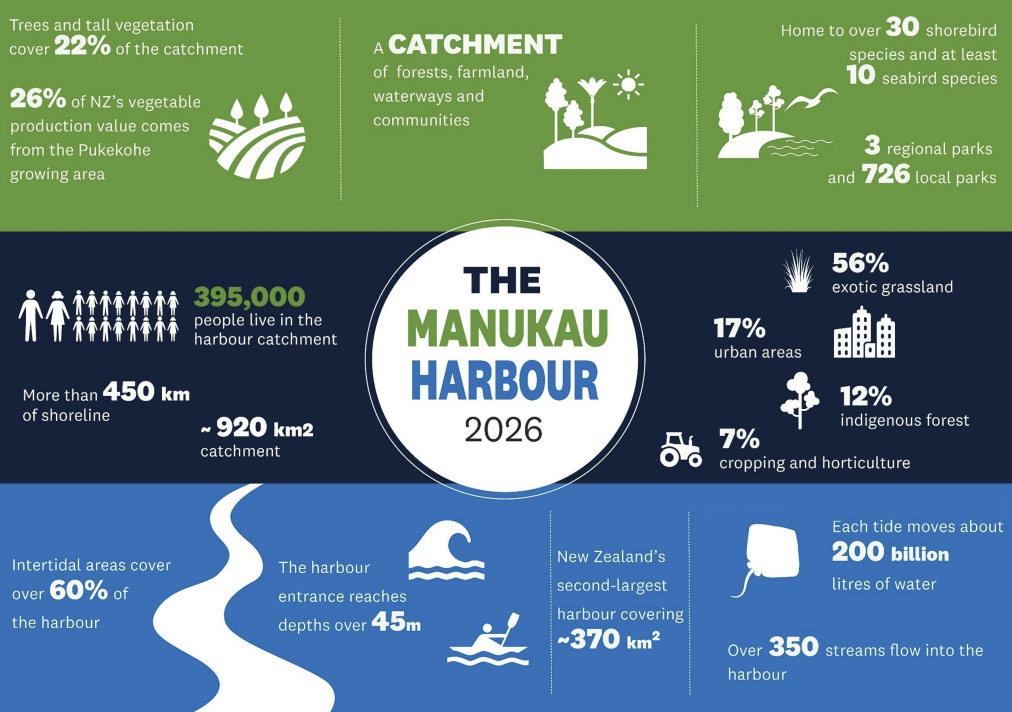
Our harbour at a glance
The Manukau is New Zealand's second-largest harbour, and it's a big, busy place to look after.
The good news
There's plenty worth celebrating, and a lot of it comes down to the harbour's natural resilience.
Coastal water quality has improved since the early 2000s across much of the harbour.
Metal contamination in harbour sediments is generally low. Most sites sit below levels where ecological impacts are expected, likely thanks to strong tidal flushing and mixing.
The Māngere Inlet is getting cleaner. It still has the highest metal levels in the harbour, but copper, lead and zinc there have kept declining since monitoring began in 1998.
Sandflats are in good shape. Most open sandflat sites rate Good or Excellent for the health of the creatures living in the sediment.
A surprise champion: the Auckland Airport site. It has the highest ecological health rating across all of Auckland's major harbours.
Harbour ecology has improved since the early 2000s, although council will keep watching recent changes in sediment organic content.
Where the harbour is struggling
The inner harbour and its tidal creeks are carrying the weight of what happens on land.
Nutrients are elevated in the inner harbour. Extra nitrogen feeds phytoplankton (microscopic algae), which lowers water clarity and causes swings in dissolved oxygen.
Some sites are now heading the wrong way. After years of improvement, nutrient levels are rising again at some monitoring sites, including Puketutu Point.
Tidal creeks are struggling. Sites in the upper creeks and inlets, such as parts of Pāhurehure, Anns Creek and Waiuku, are more often rated Marginal or Poor.
Mud is the main culprit. Fine sediment washing off the land smothers the shellfish, worms and crabs that keep the seafloor healthy.
Zinc is creeping up at some Pāhurehure Inlet sites. Levels are still low, but it's a trend worth watching.
Ki uta ki tai: on the land and in the streams
What happens on the whenua (land) ends up in the harbour. That's the heart of ki uta ki tai, from the mountains to the sea.
Streams get worse as they move from forest to farm to town. Faecal bacteria, nutrients and water temperature all rise, and dissolved oxygen drops. Headwater streams in native bush, like the upper Waipokapū, are cool, shaded and full of life. Lowland streams like the Papakura have little shade, too many weeds and high nutrient and bacteria levels.
Insect life is poor in 9 of 12 monitored streams. Freshwater insects are one of the best measures of stream health.
Water is too warm in many streams, mostly from a lack of shade.
Nitrate is a long-standing problem in Pukekohe groundwater, sometimes exceeding drinking-water guidelines. Some spring-fed streams exceed national freshwater standards.
Urban groundwater shows signs of stormwater contamination.
Soils under intensive land use show nutrient enrichment and compaction.
Wetlands are under pressure from pest plants and nutrients. Large, continuous forests are still strongholds for native plants and threatened species.
The weather is swinging harder. 2019–2020 brought low rainfall and record low river flows. Then 2023–2024 brought record summer rainfall, 250–450% of typical. Expect climate change to keep amplifying these swings.
Land use is slowly shifting. Urban areas have grown since the mid-1990s, especially around Drury, Karaka and Pukekohe, mostly on former grassland. Native vegetation has held steady, with some local gains.
Shag spotting
The Manukau is a regional hotspot for shags. It supports feeding and breeding populations of four species:
kāruhiruhi / pied shag
kawaupaka / little shag
māpunga / black shag
kawau tūī / little black shag
Shags rely on both land and sea, so they're great indicators of how the whole system is doing. Pied shag colonies cluster around the Pāhurehure Inlet, Hingaia Bridge and the Taihiki River mouth. Little shags nest at places like the Wiri Stream Reserve.
Regional shag monitoring only began in 2019, so council is still building the baseline. Community observations are helping fill the gaps, and that means you can help too.
So what does it all mean?
The scientists summed it up in a line that stuck with us: stable doesn't always mean good.
Most patterns look similar to the 2021 synthesis. Change in a harbour this size is gradual, and it can be hard to see. But steady isn't the same as healthy, especially in the inner harbour and tidal creeks. The harbour is resilient, yet its long-term health depends on how we manage the whole catchment, and on continued monitoring to tell us whether it's working.
Where the Revitalise Manukau Harbour strategy comes in
What you can do
The harbour's health is decided upstream, which means everyone in the catchment has a part to play.
Volunteer in the next planting season. Shade cools streams, and roots hold back mud. Community groups can apply for plants for next season in our previous blog post, or reach out via email.
Keep your drains clean. Everything that goes down a stormwater drain ends up in the harbour, from car-wash suds to paint to grass clippings.
Join a clean-up with Sea Cleaners or a local group near you. See more on our Events calendar.
Check, clean and dry your boats, trailers and gear to keep marine pests out.
Log your shag sightings and other wildlife observations at iNaturalist
Come to a Forum meeting. The next public meeting is on Friday 11 December, 12:15pm, at the Puketāpapa Local Board office. Anyone can attend and speak, please send an email to manukauharbourforum@aucklandcouncil.govt.nz beforehand so we can make time for you.
Want to dig deeper?
Technical reports: knowledgeauckland.org.nz
Environmental data portal: environmentauckland.org.nz
Questions about the data: Environmentaldata@aklc.govt.nz
The full synthesis report: Auckland Council Environmental Evaluation and Monitoring Unit, A synthesis of State of the Environment monitoring in the Manukau Harbour (July 2026)
Ngā mihi to the EEMU team for their mahi in the mud!
